# Collecte de données et cartographie
# Base de données environnementales
### Structuration des données environnementales
Voilà les données renseignées dans la base de données opensensemap [https://docs.opensensemap.org/#api-Measurements](https://docs.opensensemap.org/#api-Measurements)
A priori la variable physico-chimique mesurée est renseignée dans le champ "phenomenon"
[https://docs.opensensemap.org/#api-Measurements-getDataMulti](https://docs.opensensemap.org/#api-Measurements-getDataMulti)
Et chaque "sensor" mesure un "phenomenon" renseigné dans le champ "title"
[https://docs.opensensemap.org/#api-Measurements-getLatestMeasurementOfSensor](https://docs.opensensemap.org/#api-Measurements-getLatestMeasurementOfSensor)
Bref toute la réflexion qu'on pensait devoir avoir sur la structuration des données environnementales mesurées dans une base est dispo dans cette doc'. Y'a qu'à rejoindre le projet SenseBox / OpenSensemap je dirais. Et exploiter les résultats pour valider les modèles de Roland. On peut éventuellement créer notre propre "SenseBox" si les leur ne répondent pas à notre cahier des charges (type et qualité des données valeurs mesurées).
### Installation et configuration d'un Serveur MQTT
Installer l'application Mosquitto sur le serveur YunoHost du FabLab fan.ynh.fr
[https://innovation.iha.unistra.fr/books/1-fablab-vos-projets/page/installer-un-serveur-avec-la-distribution-linux-yunohost](https://innovation.iha.unistra.fr/books/1-fablab-vos-projets/page/installer-un-serveur-avec-la-distribution-linux-yunohost)
Installer le paquet mosquitto\_clients sur un PC (Terminal Linux bash) pour tester le serveur/broker MQTT
[https://shape.host/resources/comment-installer-mosquitto-mqtt-sur-debian-12](https://shape.host/resources/comment-installer-mosquitto-mqtt-sur-debian-12)
[https://forum.chirpstack.io/t/mosquitto-sub-with-connection-refused-not-authorised/666](https://forum.chirpstack.io/t/mosquitto-sub-with-connection-refused-not-authorised/666)
#### Tester la communication sur le réseau local
#### Tester la communication sur internet
[https://github.com/YunoHost-Apps/mosquitto\_ynh/issues/22](https://github.com/YunoHost-Apps/mosquitto_ynh/issues/22)
### Créer une nouvelle station via REST HTTP API
- Types de stations supportées : [https://tutorials.opensensemap.org/category/devices/](https://tutorials.opensensemap.org/category/devices/)
- Ajouter une station supportée ou non : [https://docs.opensensemap.org/#api-Boxes-postNewBox](https://docs.opensensemap.org/#api-Boxes-postNewBox)
A priori l'approche la plus propre serait d'utiliser un type de station existant ou de créer un nouveau type de station "communautaire". Sinon on peut simplement envoyer de la donnée sans créer de type de station, mais c'est plus pour du test.
#### Créer un nouveau type de station via Sensor.Community
[https://tutorials.opensensemap.org/devices/devices-luftdaten/#3-anpassung-bestehender-ger%C3%A4te](https://tutorials.opensensemap.org/devices/devices-luftdaten/#3-anpassung-bestehender-ger%C3%A4te)
### Publier les données d'un ESP32 vers OpenSenseMap via MQTT
[https://www.elektormagazine.fr/review/afficher-des-donnees-de-capteurs-esp32-sur-la-plateforme-opensensemap](https://www.elektormagazine.fr/review/afficher-des-donnees-de-capteurs-esp32-sur-la-plateforme-opensensemap)
[https://edu.books.sensebox.de/en/](https://edu.books.sensebox.de/en/)
[](https://innovation.iha.unistra.fr/uploads/images/gallery/2025-05/FOSimage.png)
- On peut envoyer des données vers les serveurs openSenseMap en publiant des messages MQTT au format `.json` (array ou object) ou `.csv` sur un broker (serveur MQTT) public
- La documentation de l'API MQTT se trouve là : [https://docs.opensensemap.org/#api-Boxes-postNewBox](https://docs.opensensemap.org/#api-Boxes-postNewBox)
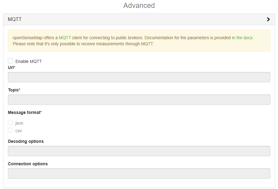
#### Paramètres pour une senseBox connectée via MQTT
| Champ | Type | Description |
|---|
| enabled | Boolean | enable or disable mqtt
Valeur par défaut : `false`
|
| url | String | the url to the mqtt server.
|
| topic | String | the topic to subscribe to.
|
| messageFormat | String | the format the mqtt messages are in.
Valeurs autorisées : `"json"`, `"csv"`
|
| decodeOptions | String | a json encoded string with options for decoding the message. 'jsonPath' for 'json' messageFormat.
|
| connectionOptions | String | a json encoded string with options to supply to the mqtt client (https://github.com/mqttjs/MQTT.js#client)
|
#### Publication en MQTT
- Le paramètre `messageFormat` spécifie à l'API sous quel format les mesures sont envoyées.
- Un maximum de 2500 valeurs peuvent être envoyées à la fois (Maximum count of values)
- Les formats acceptés sont listés dans [Measurements/Post mutliple new Measurements](https://docs.opensensemap.org/#api-Measurements-postNewMeasurements) et expliqués ci-dessous
##### Pour le csv
- Envoyer d'abord un header `content-type: text/csv`
- Puis envoyer une valeur par ligne au format `sensorId,value,[createdAt]` (pas de header, `[createdAt]` est un timestamp optionnel au format RFC 3339)
```
sensorID,value
anotherSensorId,value,RFC 3339-timestamp
sensorIDtheThird,value
anotherSensorId,value,RFC 3339-timestamp,longitude,latitude
anotherSensorId,value,RFC 3339-timestamp,longitude,latitude,height
...
```
#### Pour le JSON
- JSON Array
- objects with the keys sensor, value and optionally createdAt and location
- Specify the header `content-type: application/json`
- If Location Values are posted, the Timestamp becomes obligatory
```
[
{"sensor":"sensorID", "value":"value"},
{"sensor":"anotherSensorId", "value":"value", "createdAt": "RFC 3339-timestamp", "location": [lng,lat,height]}
...
]
```
- JSON Object :
- the keys of the object are the sensorIds
- the values of the object are either
- just the `value` of your measurement
- or an array of the form `[value, createdAt, location]`. `createdAt` and `location` values are optional.
```json
{
"sensorID": "value",
"anotherSensorID": ["value"]
"sensorID3": ["value", "createdAt as RFC 3339-timestamp"],
"sensorID4": ["value", "createdAt as RFC 3339-timestamp", "location latlng-object or array"],
}
```
##### Header
| Champ | Type | Description |
|---|
| Authorization | String | Box' unique access\_token. Will be used as authorization token if box has auth enabled (e.g. useAuth: true)
|
##### Paramètres pour la communication des mesures
| Champ | Type | Description |
|---|
| luftdatenoptionnel | String | Specify whatever you want (like `luftdaten=1` ou `luftdaten=true`). Signals the api to treat the incoming data as luftdaten.info formatted json.
|
| hackairoptionnel | String | Specify whatever you want (like `hackair=1` ou `hackair=true`). Signals the api to treat the incoming data as hackair formatted json.
|
| senseBoxId | String | the ID of the senseBox you are referring to.
|
- Standard de format JSON (Object) par luftdaten.info
The API now tries to convert the `JSON objects` in the `sensordatavalues` key to the openSenseMap JSON Array format. Sensors are matched by the key `value_type` against the `title` of the sensors of this box. `SDS_P1` matches sensors with title `PM10`, `SDS_P2` matches sensors with title `PM2.5`. You can find all matchings in the source code of the openSenseMap-API (`lib/decoding/luftdatenHandler.js`)
```json
{
"sensordatavalues": [
{
"value_type": "SDS_P1",
"value": "5.38"
},
{
"value_type": "SDS_P2",
"value": "4.98"
}
]
}
```
- Standard de format JSON (Values) par hackAIR
The API now tries to convert the `JSON values` in the `reading` key to the openSenseMap JSON Array format. Sensors are matched by the key `sensor_description` against the `title` of the sensors of this box. `PM2.5_AirPollutantValue` matches sensors with title `PM2.5`, `PM10_AirPollutantValue` matches sensors with title `PM10`. You can find all matchings in the source code of the openSenseMap-API (`lib/decoding/hackAirHandler.js`)
```json
{
"reading": {
"PM2.5_AirPollutantValue": "7.93",
"PM10_AirPollutantValue": "32.63"
},
"battery": "5.99",
"tamper": "0",
"error": "4"
}
```
##### Formats acceptés pour la localisation
| Champ | Type | Description |
|---|
| lat | Number | Latitude between -90 and 90
|
| lng | Number | Longitude between -180 and 180
|
| heightoptionnel | Number | Height above ground in meters.
|
- Location Object
```json
{ "lng": 7.684, "lat": 51.972, "height": 66.6 }
```
- Location Array
```json
[7.684, 51.972, 66.6]
```
#### senseBox Bytes Format
Submit measurements as raw bytes. Set the header to `content-type: application/sbx-bytes`. Send measurements as 12 byte sensor Id with most significant byte first followed by 4 byte float measurement in little endian (least significant byte first) notation. A valid measurement could look like this:
`[ 0x59, 0x5f, 0x9a, 0x28, 0x2d, 0xcb, 0xee, 0x77, 0xac, 0x0e, 0x5d, 0xc4, 0x9a, 0x99, 0x89, 0x40 ]` but encoded as raw bytes. Multiple measurements are just multiple tuples of id and value. The number of bytes should be a multiple of 16.
##### senseBox Bytes with Timestamp Format
Submit measurements with timestamp as raw bytes. Set the header to `content-type: application/sbx-bytes-ts`. Send measurements as 12 byte sensor Id with most significant byte first followed by 4 byte float measurement in little endian (least significant byte first) notation followed by a 4 byte uint32\_t unix timestamp in little endian (least significant byte first) notation. A valid measurement could look like this:
`[ 0x59, 0x5f, 0x9a, 0x28, 0x2d, 0xcb, 0xee, 0x77, 0xac, 0x0e, 0x5d, 0xc4, 0x9a, 0x99, 0x89, 0x40, 0x34, 0x0c, 0x60, 0x59 ]` but encoded as raw bytes. Multiple measurements are just multiple tuples of id, value and timestamp. The number of bytes should be a multiple of 20.
### Ressources
[https://www.urbanheatislands.com/uhi-web-maps](https://www.urbanheatislands.com/uhi-web-maps)
Projet Capt'air : [https://wp.unil.ch/captographies/](https://wp.unil.ch/captographies/)
# openSenseMap
[](https://innovation.iha.unistra.fr/uploads/images/gallery/2025-05/image.png)
[](https://innovation.iha.unistra.fr/uploads/images/gallery/2025-05/U3Qimage.png)
[](https://innovation.iha.unistra.fr/uploads/images/gallery/2025-05/HEPimage.png)
- Ajouter un nouveau modèle de station de mesure
[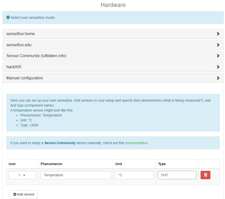](https://innovation.iha.unistra.fr/uploads/images/gallery/2025-05/gleimage.png)
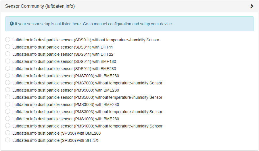
- Ou contribuer en créant une nouvelle station sur Sensor.Community en suivant cette doc' [https://tutorials.opensensemap.org/devices/devices-luftdaten/#3-anpassung-bestehender-ger%C3%A4te](https://tutorials.opensensemap.org/devices/devices-luftdaten/#3-anpassung-bestehender-ger%C3%A4te)
[](https://innovation.iha.unistra.fr/uploads/images/gallery/2025-05/1scimage.png)
- Configurer le broker MQTT pour que le client openSenseMap puisse s'y connecter
[](https://innovation.iha.unistra.fr/uploads/images/gallery/2025-05/FOSimage.png)
On ne peut pas récupérer de données via MQTT, seulement en envoyer. Il faut passer par l'API HTTP REST pour exploiter les données.
# Station de mesure de l'eau
Il existe de nombreuses stations, matériels et documentations mis à disposition par le projet SenseBox : [https://sensebox.de/en/products](https://sensebox.de/en/products)
Nous développons notre propre station de mesure de la qualité de l'eau pour une intégration au projet openSenseMap. La station pédagogique la plus proche pour les mesures de l'air est la SenseBox Edu :
- [https://edu.books.sensebox.de/en/](https://edu.books.sensebox.de/en/)
- [https://sensebox.de/en/products-edu](https://sensebox.de/en/products-edu)
# Station de mesure de l'air
Matériel pédagogique pour la SenseBox
- Projets : [https://sensebox.de/en/projects](https://sensebox.de/en/projects)
- Matériel pédagogique (Cartes d'apprentissage) : [https://sensebox.de/en/material](https://sensebox.de/en/material)
- Documentation en ligne : [https://docs.sensebox.de/](https://docs.sensebox.de/)
- senseBox:Edu S2 : [https://docs.sensebox.de/en/docs/boards/mcus2/mcu-s2-overview/?board=edus2](https://docs.sensebox.de/en/docs/boards/mcus2/mcu-s2-overview/?board=edus2)